Greenspace Asset Mapping
Greenspace Asset Mapping
Digital Mapping Resource
SAGP are developing a publicly accessible digital mapping resource for partners which enables information about greenspace and green infrastructure in this area to be recorded, analysed, readily shared and used to inform local decision making.
The mapping currently covers the expanding ‘urban areas’ of Salisbury, Wilton and Laverstock and Ford and it is hoped to extend the coverage to include the full extent of the nine parishes centred on Salisbury. This resource is available for partners and supporters to use, as well as other community groups, parish councils, planners, and greenspace managers but is not to be used for commercial purposes.
By mapping where the different types of green spaces assets are, broadly what their function is, how well they are connected, where the gaps are and the potential for protection and making improvements, SAGP believe it will help local people in this part of South Wiltshire to appreciate and understand the bigger picture as well as the detail.
The aim is to use the mapping to develop a local green infrastructure strategy that will guide policy making and inform more specific management decisions and resource allocation. It can also be used to support the development of neighbourhood plans in this area and address the issue of how to protect, plan and provide for the essential infrastructure, like green infrastructure, which cuts across administrative boundaries.
Using the SAGP Viewer
The Salisbury Area Greenspace Asset Map is an interactive map which can be viewed here. There is a detailed typology on which it is based. Further information can be accessed in the attribute table. Users also have access to a range of related environmental data mapped by other organisations which, although already freely available to members of the public to download, has been brought together to provide a one-stop shop for information about local greenspace.
GIS Data
SAGP have permission from Wiltshire Council to use their OS licence and server. The GIS data is derived from Ordnance Survey Mastermap and can only be downloaded by users with appropriate Ordnance Survey licence arrangements.
Other organisations and individuals, for example, local authorities, parish councils, researchers & academic institutions with appropriate OS licence agreements can request a copy of the data. If you have access to OS Mastermap under another licence type, please include full details & your licence number.
Whilst SAGP has endeavoured to ensure the greenspace asset baseline data is reliable, the accuracy and currency cannot be guaranteed, and the user is advised to make their own checks.
Anybody wanting their own copy of the greenspace datasets can contact us or are advised to contact the organisation that originated any of the other data we hold.
SAGP’s GIS Capability
SAGP also has its own GIS capability for managing and developing the local greenspace asset data and other data collected by volunteers. Put together with other environmental data a whole range of mapping can be generated to illustrate different topics and issues including the different types of greenspace, their primary function, how well they are connected, their value for wildlife and biodiversity and their value as landscape setting.
Greenspace Mapping Methodology
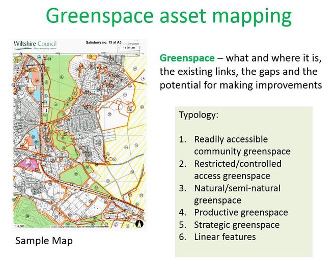
Typology for greenspace asset survey
Using Google and BING aerial mapping as well as local knowledge, SAGP volunteers surveyed and mapped greenspace assets by type and primary function according to an agreed typology.
There are five main classes of greenspace – accessible greenspace, restricted access greenspace, natural greenspace, productive greenspace and strategic greenspace.
A database has been set up and the mapping makes it possible to see where and what greenspaces there are over this part of South Wiltshire, and more importantly where the gaps are and the potential for improvement and protection.
SAGP are particularly grateful to Wiltshire Council for supporting the digital mapping project both in kind and with funding.
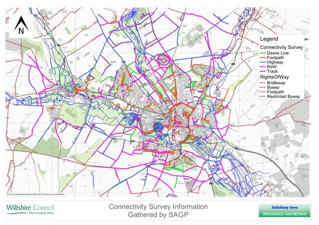
Connectivity survey
Working with the Salisbury Air Quality Management Group, Walking for Health, and the local cycling group, COGS, volunteers have surveyed and mapped all existing routes so that missing links can be established. These routes included Rights of Way, footpaths, tracks, highways without footways and desire lines, and are often associated with linear greenspace.
The overall aim is to use this information to develop a strategy for improving local connectivity for pedestrians and cyclists, and to ensure that new developments are properly linked in to a comprehensive network of green infrastructure. It is hoped this will be incorporated into future Supplementary Planning Guidance as part of a more strategic plan and there will be an opportunity to contribute this information to Wiltshire Council’s Transport Strategy Refresh in the new year.
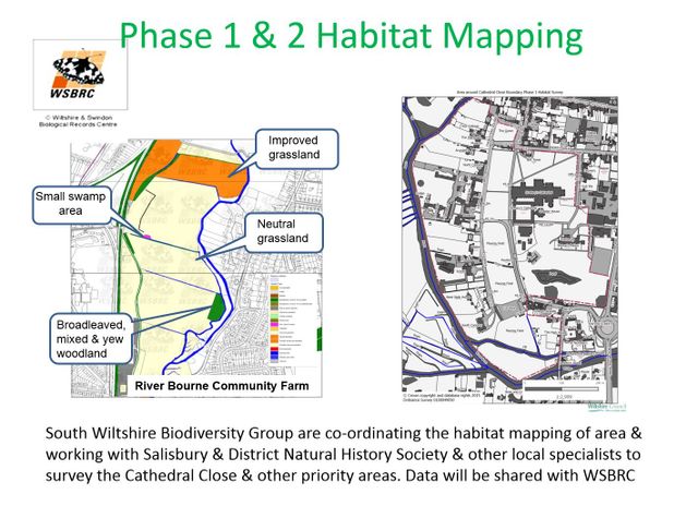
Habitat Mapping
SAGP are working with South Wiltshire Biodiversity Group who are coordinating the habitat mapping of the area to fill gaps in the Habitat Inventory for the Salisbury Area. Volunteers from SWBD, SAGP and the Salisbury and District Natural History Society have been carrying out local surveys. This information will be shared with and used exclusively by the Wiltshire and Swindon Biological Record Centre. However, it can be used by SAGP to develop a biodiversity reference map indicating where Habitats of Principle Importance are found, as well as other wildlife rich habitats and areas of green infrastructure value and potential for enrichment.
Using the Data
A range of plans can be generated for different purposes – for analysis and assessment and, for example, engaging local people in the neighbourhood planning process through exhibitions and presentations, and more generally for raising awareness about the value and importance of greenspace and green infrastructure.
However, further information is needed about what people think about their local green spaces – what they like and don’t like about them, how they are used; how they could be improved to better meet the needs of local people of all ages. Assessments are also required as to the other important functions they perform such as the contribution they make to local distinctiveness and landscape setting, and what ecosystem system services they deliver. This will enable the gaps and the potential for making improvements to be identified, and it will be possible to evaluate where more protection is needed.
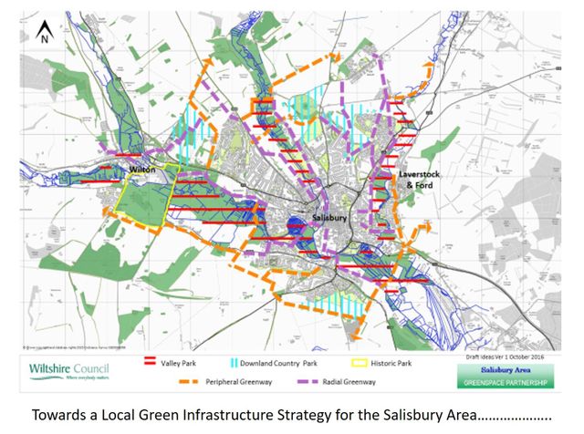
Towards a Local Green Infrastructure Strategy
Using all the data that has been collected so far, it is possible to see how a green infrastructure strategy could start to emerge for this area. This is very much a draft plan and ideas are still being explored. However, for example, there is potential for maintaining and protecting the attractive character and openness of the river valleys that define this area as green fingers or valley parks because they penetrate into the heart of the city and provide such magnificent views to landmarks like the Cathedral and Old Sarum, but also provide valuable corridors for people and wildlife.
There is potential to extend the idea of downland country parks to ensure the distinctive chalk hills surrounding the main urban areas are protected from development. There is also potential to develop an effective network and hierarchy of safe traffic free greenways for cyclists and those on foot linking homes with schools and other services, linking the city centre with the suburbs and with the countryside beyond.